


Broadband EMDAR

Electromagnetic Direction and Ranging (EMDAR) is a passive sensor technology that detects emissions along the EM spectrum to identify and track other vessels. The system is passive because it does not emit any EM to make its detection (in the way that RADAR does with radio waves). Instead, the system detects EM radiation falling onto its sensors and calculates likely distance using dispersal patterns, a process very similar to SONAR.
The advantage of the passive system is that it does not provide any EM emission for an opposing vessel to detect. The disadvantage is that passive systems can only achieve relatively weak readings, sometimes difficult to distinguish from background radiation. Dispersal patterns also become increasingly less predictable over distance, making range estimations less certain.
Broadband EMDAR
EMDAR uses broadband detection techniques which estimate the range of an emission source by analysing EM dissipation patterns, but are less useful for identifying bearings (direction). As such, a single EMDAR array cannot estimate the speed or course of an object.
Multiple EMDAR arrays with different directional orientations are used to provide additional data for estimating speed and course. The vessel has a forward-facing array and a pair of lateral arrays (port and starboard). Exhaust from the impulse engines prevents the use of an aft array, but a remote array can be launched to provide EMDAR coverage astern.
By comparing the behaviour of an object across multiple EMDAR arrays, conclusions can be drawn on and object’s course and speed.
Waterfall Interface
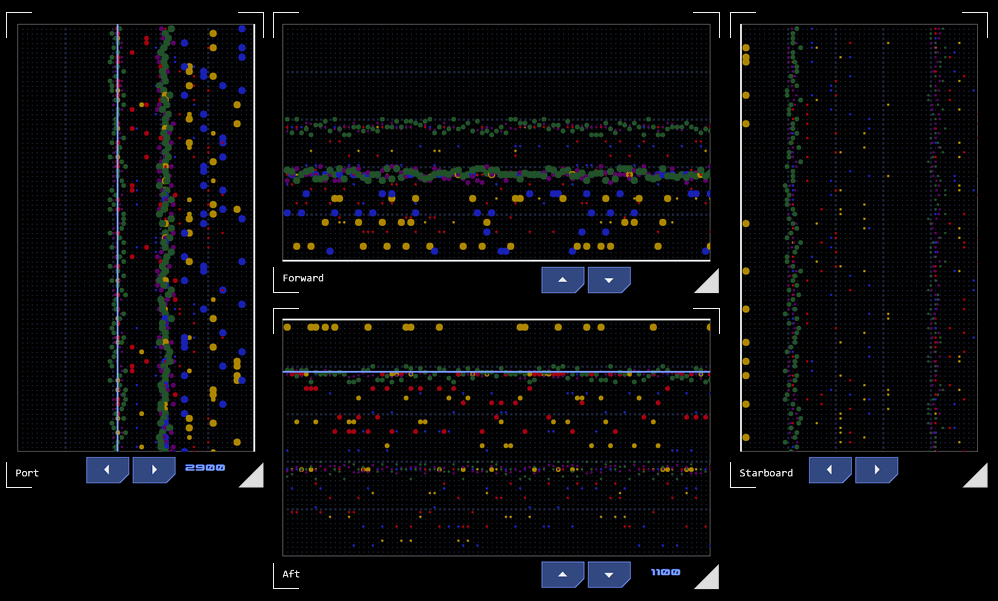 Each EMDAR array presents detection data as a grid defined by range and time axes. A detection is represented as a dot, its position indicating estimated range and the time since detection. The colour of the dot represents the EM range of the detected emission and the dot’s size represents the intensity of the emission.
Presenting historical detection data allows patterns to form, typically as a line (or trail) across the display (hence the name waterfall for these types of visualisations). These patterns can provide hints as to course and speed.
Example
By way of example, sample EMDAR displays are shown in the picture to the right.
This example is simplified in that it shows only static contacts and the vessel itself is not moving. Were either in motion, the waterfall trails would appear to "drift" in the direction of travel. For example, if a contact was getting closer to the vessel, the top (or left side) of the trail representing the most recent detections would have a closer range than the lower (or right) end of the trail which contains less recent detections. When trail drifts are considered across multiple arrays, an experienced EMDAR operator is able to discern a great deal about a TSMO's relative course and maneuvering.
Contacts
 The crew monitoring EMDAR can declare a contact if they believe a detection represents the location of a TSMO, passing the coordinates to the Contact Board. The tactical officer will generally alert the conn to the contact's creation along with whatever additional information they can provide such as heading, range, maneuvering patterns, etc.
It is likely that multiple contacts will be generated by the same TSMO over time. Once multiple contacts are on the board, it may be easier to infer the TSMO's course, helping to focus the search. To facilitate this, each TSMO is given a designation, so that contacts associated with it are easily identified. Where the crew suspects they are monitoring multiple TSMOs, each is given a different designation.
Four designations are available. Each designation is associated with a colour (when displayed don the tactical overlay, for example). The first letter of the colour is associated with the designations' NATO radio code letter to assist recollection.
Sierra: This designation is coloured silver (grey).
Bravo: This designation is coloured blue.
Tango: This designation is coloured tan (gold/yellow).
Victor: This designation is coloured violet (purple).
The designation is accompanied by a identifying number that is unique to each contact.
Transition to Narrowband
A designated contact will appear on the Contact Board and the system will automatically track the identified location in space relative to the vessel's own movement. At this stage the system does not have sufficient information to track the object that is emitting the EM, so each contact represents a fixed point in space.
In order to automatically track the location of a TSMO, a narrowband EMDAR array must be used. As narrowband EMDAR can only analyse a small area of space, it must be directed toward the TSMO's location in order to achieve a track.
Once broadband EMDAR has estimated the TSMO's location with sufficient accuracy, a contact may be assigned to a narrowband array for tracking.
Once a contact is tracked, any other contacts with the same designation used as part of the tracking process are cleared. The track's designation is now used to identify its target profile, such as "friendly" (bravo), "threat" (tango) or "neutral" (victor), leaving sierra for contacts with unknown posture.
Categories:
Concept Site
Immersive sci-fi and how to join the adventure
Crew Site
Information and tools for ISDC crew members


